Stages 1 and 2
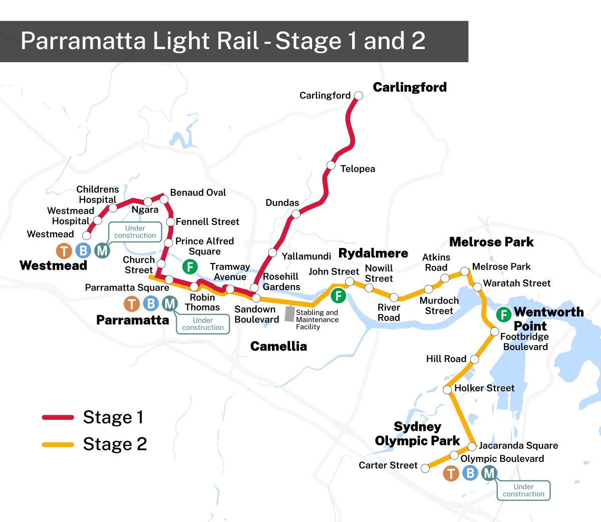
A static map displaying stages 1 and 2 of the Parramatta Light Rail.
Image
Download Parramatta Light Rail Stages 1 and 2 map (JPG 1.3MB)A static map displaying stages 1 and 2 of the Parramatta Light Rail. Stage 1 will have 16 stops across Carlingford, Camellia, Parramatta CBD, Parramatta North and Westmead. Stage 2 will have 14 stops across Rydalmere, Ermington, Melrose Park, Wentworth Point, Sydney Olympic Park, and Carter Street.
From the left-hand of the map, Stage 1 extends from the west to the north-east starting at Westmead heading north-east up Hawkesbury Road, and then proceeds further east to Factory Street. From there Stage 1 goes south down Church Street, and then heads east again down Macquarie Street, then George Street, then Tramway Avenue then continues north-east all the way up to Carlingford where it concludes.
Stage 2 starts at the right-hand side of the map at Carter Street, and heads east down Dawn Fraser Avenue, then goes north up Australia Avenue. From there it heads east again down Hill Road, then north again to cross the Parramatta River and down Waratah Street. Then it continues west down Boronia Street, then South Street, and then south-west where there are 2 different routes, one being the preferred route that goes down from South Street, crosses the Parramatta River, then west down Grand Avenue.
The second is an alternative route under consideration for Stage 2 that instead goes west shortly after South Street, and crosses the Parramatta River then meets Grand Avenue. Further down Grand Avenue there is a stabling and maintenance facility on the south side of the route, which then continues to Camellia where it meets Stage 1.
From here it continues north-west down Tramway Avenue to the first interchange stop, then down George Street to another interchange stop, then down Macquarie Street to the last interchange stop, which is the final part of the preferred route for Stage 2. A small section that continues north-west off this is a turnback option that is under consideration.
Stage 1

Image
Download Parramatta Light Rail Stage 1 map (JPEG 914.24KB)A static map that displays Stage 1 of the Parramatta Light Rail route. The route starts on the left-hand side of the map at the Westmead light rail stop, just above Westmead railway station. It heads north-east up Hawkesbury Road where it stops at Westmead Hospital and then Children's Hospital. From there it proceeds further east to the Ngara stop on Factory Street, then goes south down Church Street to the Benaud Oval, Fennell Street, Prince Alfred Square and Church Street stops. The route then heads east down Macquarie Street to the Parramatta Square and Robin Thomas stops. Then it continues down George Street, then to the Tramway Avenue stop, and then turns north-east stopping at Rosehill Gardens, Yallamundi, Dundas, and Telopea, with the last stop at Carlingford.
Stage 2

Image
Download Parramatta Light Rail Stage 2 map (PNG 1.1MB)A static map that displays stage 2 of the Parramatta Light Rail. The route starts on the left-hand side of the map at the Parramatta Square light rail stop, located below the ferry stop, and above the train station, bus stop and a metro station that’s under construction.
It heads east where it stops at Robin Thomas and Tramway Avenue, then continues east through Camellia where it stops at Sandown Boulevard and where the Stabling and Maintenance Facility is located. It then continues north-east to Rydalmere where it stops at John Street near a Ferry stop, then continues south-east and stops at Nowill Street and River Road.
From there it goes north-east into Melrose Park stopping at Murdoch Street, Atkins Road and the Melrose Park stops. It then heads down south-east, stopping at Waratah Street, then crossing over Parramatta River Into Wentworth Point stopping at Footbridge Boulevard below a ferry stop.
The route continues south-west stopping at Hill Road and Holker Street, before heading south-east into Sydney Olympic Park where it stops at Jacaranda Square and Olympic Boulevard, just above train and bus stops as well as a metro stop that is under construction. This route then concludes at the last stop at Carter Street.
Stage 2 Map Overview

Image
Download Parramatta Light Rail Stage 2 map (PNG 1.1MB)A static map that displays stage 2 of the Parramatta Light Rail. The route starts on the left-hand side of the map at the Parramatta Square light rail stop, located below the ferry stop, and above the train station, bus stop and a metro station that’s under construction.
It heads east where it stops at Robin Thomas and Tramway Avenue, then continues east through Camellia where it stops at Sandown Boulevard and where the Stabling and Maintenance Facility is located. It then continues north-east to Rydalmere where it stops at John Street near a Ferry stop, then continues south-east and stops at Nowill Street and River Road.
From there it goes north-east into Melrose Park stopping at Murdoch Street, Atkins Road and the Melrose Park stops. It then heads down south-east, stopping at Waratah Street, then crossing over Parramatta River Into Wentworth Point stopping at Footbridge Boulevard below a ferry stop.
The route continues south-west stopping at Hill Road and Holker Street, before heading south-east into Sydney Olympic Park where it stops at Jacaranda Square and Olympic Boulevard, just above train and bus stops as well as a metro stop that is under construction. This route then concludes at the last stop at Carter Street.
Active Transport Link
Image
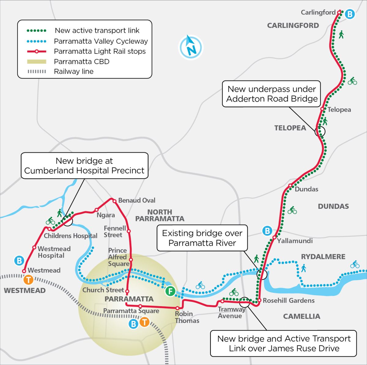
Download Parramatta Light Rail Transport Active link map (JPEG 486.14KB)A static map that displays the Parramatta Light Rail route as well as the active transport link and Parramatta Valley cycleway. The light rail route starts on the left-hand side of the map at the Westmead light rail stop, just above the Westmead railway station. It heads north-east where it stops at Westmead Hospital and then Children's Hospital.
From there it proceeds further east to the Ngara stop, then goes south to the Benaud Oval, Fennell Street, Prince Alfred Square and Church Street stops. The route then heads east to the Parramatta Square and Robin Thomas stops. It then continues east to the Tramway Avenue stop, then turns north-east stopping at Rosehill Gardens, Yallamundi, Dundas, and Telopea, with the last stop at Carlingford.
The active transport link is in 2 parts. The first part is on the left-hand side of the map, and starts at the Children's Hospital light rail stop, and concludes shortly after crossing the new bridge at Cumberland Hospital Precinct. The second active transport link starts on the right-hand side of the map at the Tramway Avenue light rail stop, and follows the light rail route as it turns north-east going past the Yallamundi, Dundas, Telopea stops and then concludes at Carlingford.
The Parramatta Valley Cycleway starts on the left-hand side of the map along the north side of Parramatta River, south of the Children's Hospital light rail stop. The cycleway follows the river through the Parramatta CBD where the cycleway is available on both sides of the river. Just before the Ferry stop the north and south sides of the cycleway meet, then continue to follow the river on the north side until meeting the active transport link, the Parramatta Light Rail route and an existing bridge. From here it diverges from the river into Rydalmere, but then returns to following the river again.
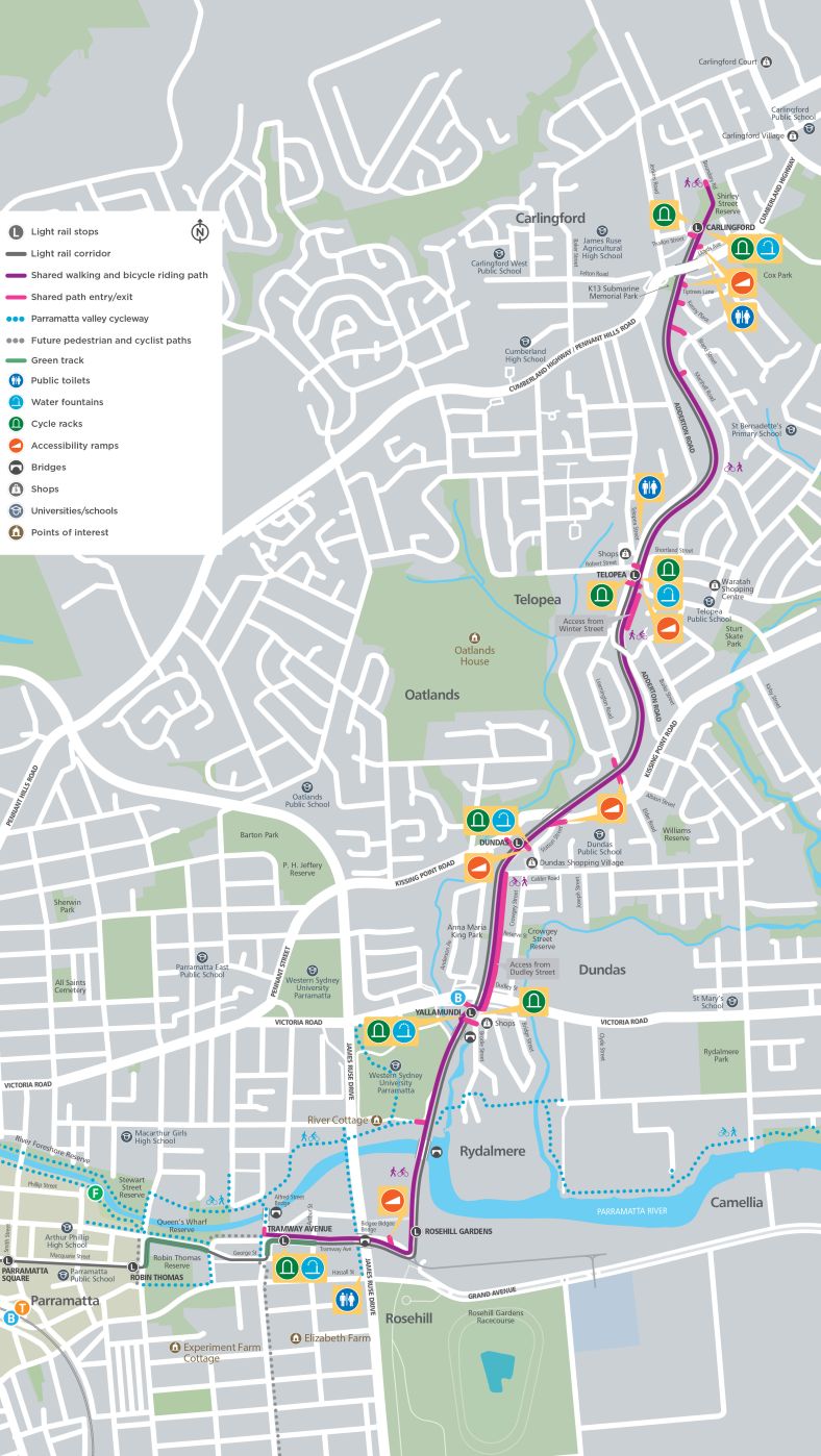
A static map displaying stage 1 of the Parramatta Light Rail. From the left-hand of the map, stage 1 extends from the west to the north-east going up Factory Street, then goes south down Church Street, where it stops at the Benaud Oval stop, just before St Patricks Cemetery, Richie Benaud Oval, Pennant Hills Road and Albert Street. From there it continues south to the Fennel Street stop, then the Price Alfred Square stop after Victoria Road and right next to Price Alfred Park. The route continues south across the Parramatta River, past Philip Street, and stops at the Church Street stop. From there it heads east again down Macquarie Street, and stops at Parramatta Square at Smith Street, located above the train station and bus stop. It then continues further east past Parramatta Public School and Arthur Philip High School to the Robin Thomas stop, opposite the Robin Thomas Reserve.
The route proceeds briefly north and then east down George Street, then continues onto Tramway Avenue where it stops again - a stop which includes water fountains and cycle racks. This then continues through James Ruse Drive over Bidgee Bidgee Bridge, then heads north-east stopping at Rosehill Gardens, then continuing through Rydalmere past Western Sydney University Parramatta, where it then reaches the Yallamundi stop, near Brodie Street. This stop has water fountains and cycle racks and is located near a major bus stop and shops. The route then continues through Dundas, past Anna Maria King Park, before stopping at the Dundas stop near Kissing Point Road, Dundas Shopping Village and Station Street.
This stop has water fountains, cycle racks and accessibility ramps. The route then continues through Oatlands and then stops at the Telopea stop. This is located near Robert Street, Telopea Street and Shortland Street. This stop also has water fountains, cycle racks and accessibility ramps. Public toilets are also located nearby on Adderton Road. From here the route continues past St Bernadette’s Primary School, then under the Cumberland Highway where it then it concludes at its last stop in Carlingoford, very close to Shirley Street Reserve. This stop also has water fountains, cycle racks accessibility ramps and public toilets at Lloyds Avenue.
Green track
There are 2 sections of Green Track on this map. This first is directly in front of Robin Thomas Reserve, opposite the Robin Thomas Light Rail stop. Then it continues on the track heading north and then east where it stops roughly halfway down George Street. The second section is just after George Street, where the track goes north. From here the green track continues with the track down Tramway Avenue, through the Tramway Avenue stop. This section section stops just after crossing Arthur Street.
Shared walking and bicycle riding path and shared paths for entry/exit
The shared walking and bicycle path starts at the bottom middle of the map, just before the Tramway Avenue light rail stop, and provides a shared entry/exit path. This path follows the light rail track closely, as it continues east on Tramway Avenue and across Bidgee Bidgee Bridge. just after the bridge, there is a shared entry/exit path that has an accessible ramp. From here it continues following the light rail track north, through the Rosehill Gardens stop, into Rydalmere over a bridge to cross the Parramatta River.
Just after this, there is another shared entry/exit path. From here it continues parallel with the light rail track to the Yallamundi stop, where there are 2 shared entry/exit paths, 1 on each side of the station. From here the shared path widens and can be accessed from Dudley Street, and then shrinks back down just before the Dundas light rail stop, where there are 2 shared entry/exit paths, one which has an accessible ramp, water fountains and cycle racks. After the Dundas stop there is another shared entry/exit path at Station Street with an accessible ramp, and then 2 more further up, one at Leamington Road, and the other at Elder Road which also has an accessible ramp. The path continues with the light rail track where it reaches the Telopea stop. Prior to the stop, there is a widened shared path that can be accessed from Winter Street. At the stop, there is a shared path with an access ramp, water fountains and cycle racks. There is also another shared entry/exit path just after the Telopea stop. From here the path continues into Carlingford where there are shared entry/exit paths on the east side connecting to Marshall Road, Brand Street and Kenny Place. Just before Cumberland Highway, there is another with an accessible ramp.
Just before the Carlingford stop there are 2 more shared entry/exit paths. One at Lloyds Avenue, which has an accessible ramp and public toilets, and a second on Thallon Street, near cycle racks and water fountains. After the Carlingford stop the shared walking and bicycle path continues through Shirley Street Reserve and concludes where it meets Boundary Road.
Parramatta valley cycleway
The Parramatta Valley Cycleway starts on the left-hand side of the map at O'Connell Street under Bayanami Public School along the north and south side of the Parramatta River. The cycleway follows the river through the River Foreshore Reserve and past a Ferry stop until it gets to the end of Stewart Street Reserve. Here the north side of the cycleway splits into 2 paths.
The first continues slightly further up north, then heads east through the north section of Queen’s Wharf Reserve, following the curve of the Parramatta River. At the end of the reserve, the path splits. The first heads north for a short while then concludes, while the second continues east. This splits again at Alfred Street Bridge. The first goes across the bridge, and goes south past Tramway Avenue and continues until it meets George Street. The second continues east where it meets James Ruse Drive where it splits into 3 paths. The first goes north and stops at the next road. The third goes sharply south where it continues following James Ruse Drive until it meets Hassall Street. The second goes across James Ruse Drive and splits into 2 paths after River Cottage. The first path goes north through Western Sydney University Parramatta, and stops at Victoria Road. The second continues east where it goes under the light rail and shared walking and bicycle riding paths into Rydalmere, crossing over the Parramatta River and Brodie Street, then continuing east, crossing the river again where the path splits into 2 paths. The first path continues east for a short while until it meets a road, while the second goes south where it follows the river until the river changes course east which the path follows through into Camellia.
The second path after Stewart Street Reserve crosses over the river to meet the south side. This second path splits again, with one path continuing west up George Street and stops before Arthur Philip High School, with the other path going east down George Street passing through Queen’s Wharf Reserve, then turning south, then turning west at the t intersection, cutting through Robin Thomas Reserve and stopping where it meets another road.
Future pedestrian and cyclist paths
There are 3 sections of pedestrian and cyclist paths that are planned for the future. The first is at the bottom right-hand side of the map, just after the current path cuts through Robin Thomas Reserve, and goes north to meet with the paths on both sides of Parramatta River that go through Stewart Street Reserve. The second planned path connects the current path at Queen’s Whard Reserve and Tramway Avenue. Finally, the third planned path starts at George Street where it currently ends, and continues south.
Related links
Contact Parramatta Light Rail
For more information, enquiries or to lodge a complaint, please contact us:
- Phone: 1800 139 389 (24-hour community information line)
- Email: parramattalightrail@transport.nsw.gov.au
- Address: Level 7, 4 Parramatta Square, 12 Darcy Street, Parramatta NSW 2150
Follow us on Facebook:
Follow Transport for NSW
Follow us on social media.