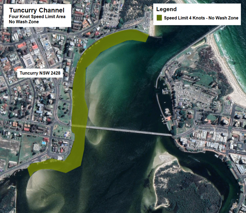
4 knot speed limit and No Wash area
Where
When
The change
Vessel operators are advised that Transport for NSW declares that the above change has occurred on the Tuncurry Channel between the Tuncurry Point Road Boat Ramp downstream to the Rockpool Kiosk, and from March 2016 the Tuncurry Channel is now a four knot speed limit and No Wash area pursuant to Section 11 of the Marine Safety Act 1998.
Speed limit and no-wash area
Due to concerns for the safety of navigation, Transport for NSW has established a Four (4) Knot Speed and No Wash Area (‘the Area’). The Area will be marked by buoys and signs.
Wallis Lake (Cape Hawke Harbour and Tuncurry Channel) Area - The navigable waters of that part of Wallis Lake and Cape Hawke Harbour known as the Tuncurry Channel enclosed by lines commencing at a point on the northern shore one hundred and twenty (120) metres west of the eastern extremity of the Rockpool breakwall in a southerly direction for eighty (80) metres thence in a westerly southerly and westerly directions at a distance of eighty (80) metres parallel to the shore to a point one thousand three hundred and fifty (1350) metres thence in a northerly direction for eighty (80) metres to a point on the northern shore one hundred and thirty (130) metres west of the Point Road Boat Launching Ramp – four knots.
Directions
Transport for NSW advises that in relation to the Area;
- Persons within the vicinity of the Area must comply with any restrictions indicated by notice in relation to the Four Knot Speed Limit. Failure to comply with any such direction is an offence (Marine Safety Act 1998, s.11(4)(b) - Maximum Penalty $1,100.00).
- Persons within the vicinity of the Area must comply with any restrictions indicated by notice in relation to the No Wash Area. Failure to comply with any such direction is an offence (Marine Safety Act 1998, s.11(4)(a) - Maximum Penalty $5,500.00).
The Tuncurry Channel is a busy waterway that has a major boat ramp, slipway, commercial boating facilities and vessel moorings. The area is frequented by a diverse range of vessels including human powered paddle craft and large sea going commercial vessels. These changes have been introduced to provide for improved safety for users of the waterway and to decrease the potential damage and dangers associated with wash created by vessels in the area. Vessels navigating through the area must do so at a speed not exceeding 4 knots, and must produce no wash.
Maps and charts affected
To see the area affected, refer to:
- Transport for NSW Boating Map – 6B (PDF 2.16MB).

Contact Transport for NSW information line
For further information concerning this navigation advice, please contact the Transport for NSW information line on:
Phone: 13 12 36
Monday - Friday
8:30am - 5:30pm
Saturday - Sunday
8:30am - 4:30pm